The PG&E Trail Makes For Great Hiking At Rancho San Antonio County Park
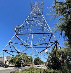
With this great weather, it was time to get out and enjoy the beauty of our area. One of the nicest hiking areas around is located in the western foothills at Rancho San Antonio County Park and Open Space Preserve. One of my favorite hikes is the PG&E Trail otherwise known as the power poles trail. The total hike is slightly over 4 5-ish miles from the valley, it has an elevation gain of over 600 feet. It is a great hike that rewards hikers with great views of the bay area and the western foothills.
Begin your hike by heading south from the main parking lot towards the equestrian parking area. Turn right, cross over a small foot bridge and the climb begins. As you walk, the western views will become better and better. About 10 minutes into the hike, there is a three-way trail head. Take the far left trail (the one heading uphill). A hundred yards ahead will be a fence that prevents bikes from proceeding further. Go through the gate and continue further. Eventually the first high voltage transmission line will come into view. Continue along the fire-trail, following the path of the transmission lines.
The trail is mostly uphill until you reach power line #3. At approximately 625 feet of elevation (from the valley floor), this is the highest point on this hike. Note, you can follow the power lines much further up the mountain but on this hike, I suggest heading back to the valley. The trail goes downhill for the next three power lines. At power line #6, there will be a trail to the right, that heads downhill. Take it for about 150 yards where it will connect with the Wildcat Loop Trail (turn right) that takes you back to the Dear Hollow Farm.
Once at the farm, follow everyone else one mile back to the parking lot. You will pass the tennis courts and the Giant California Bay tree. I would allow approximately 1.5 hours for the hike. Make sure you bring water, a snack, layered clothing and maybe a camera.


